
This post originally appeared on Go Girl Travel Network. The most common questions I am asked when I tell people I live in Iqaluit, Nunavut are, “Where is that?” and “What does it look like?”. As we wrote in our first post, these questions can easily be answered by Google. But, as we also said, we like to give our readers something a little extra, so, I have used Google Street View to craft a virtual tour of our snowy town. Scroll down to get a glimpse of Iqaluit and see some notable Street View finds.
Google Street View Iqaluit
This year on Nunavut Day, July 9th, Google launched Street View for Iqaluit, giving the world the opportunity to find out exactly “what it looks like” to live in a remote northern town.
Almost everyone who comes to Iqaluit arrives on a plane; this is because all 26 Nunavut communities are fly-in-only, meaning, no roads connecting the hamlets within the territory or to southern Canada. The lack of road access is part of what makes Nunavut remote.
So if Iqaluit is fly-in-only, then how come almost everyone arrives on a plane? How do the non-flying people get here? One awesome word: snowmobiles. You don’t need roads when you have Skidoo trails, so from about early-November to late-June, the snowmobile is a viable mode of transportation between communities, or more commonly, to get around town.
I have to be upfront about my choice in featuring this particular Street View: this is Justin, my partner, driving our Skidoo, sporting sealskin mitts, with the qamotik (wooden sled at the back) in tow. Suffice it to say that this is one of his proudest achievements.
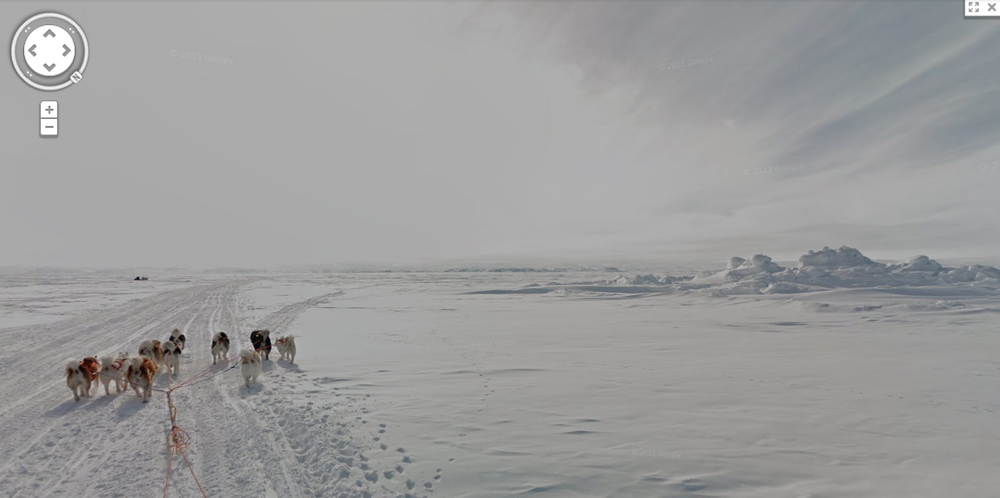
If snowmobiles are not your thing, you can kick it old school on a dog sled. Dog teams are now used mostly for sport or leisure and not as a main mode of transportation, but this traditional activity still evokes the history of pre-modern arctic living.
Also keeping history alive are these original Hudson Bay buildings. Originally built in 1914 at Ward’s Inlet, then disassembled, transported, and rebuilt near Apex in 1943, these buildings served as an outpost for the Hudson Bay Company (HBC). The narrative around HBC, its fur trade, and its influence on Canada and the people who inhabited this vast land is complicated and often dark; somehow, that past only strengthens the historical, portentous nature of the HBC buildings.
Not long after HBC set up camp in Iqaluit (then called Frobisher Bay) followed the military, but not the Canadians; it was the American military that saw Baffin Island as a good spot to build a base. Iqaluit’s military past is still visible today, such as this former barracks-turned Government of Nunavut’s Community and Government Services warehouse.
Arctic architecture isn’t only based on trading posts and military necessities; building design is also inspired by the surrounding landscape and traditional Inuit structures. Two awesome examples in Iqaluit include the Nakusuk Elementary School, which either looks like an ice block or a piece of whale blubber (you tell me), and St. Jude’s Angilican church, known colloquially as the “igloo church”.
Another architectural standout is the Inuksuk High School, sitting up on a ridge and painted a pretty sky blue. It not only looks cool, but it exemplifies cold weather functionality in its minimal use of glass, square shape, and of course, giant bowhead whale bones.
One really neat feature of Iqaluit Street View is the ability to enter some of the town’s prominent buildings. Below is your first step into Inuksuk High School via the foyer flanked by giant soapstone carvings (go through the door to see more art and an antique snowmobile!). You can also get a virtual tour of the inside of Nakasuk Elementary School and the Legislative Assembly.
By far the most interesting part of Street View is, fittingly, the view of the streets. Iqaluit doesn’t have sidewalks (though we do have posts) or traffic lights, but we do have the Four Corners, a four-way stop in Iqaluit’s downtown that every morning and evening is the site of what we like to call the “rush minute”.
And finally, it wouldn’t be a tour of Iqaluit without an igloo, now would it? This igloo was built in front of the Unikkaarvik Visitors Centre, and Google Street View lets you enter both!